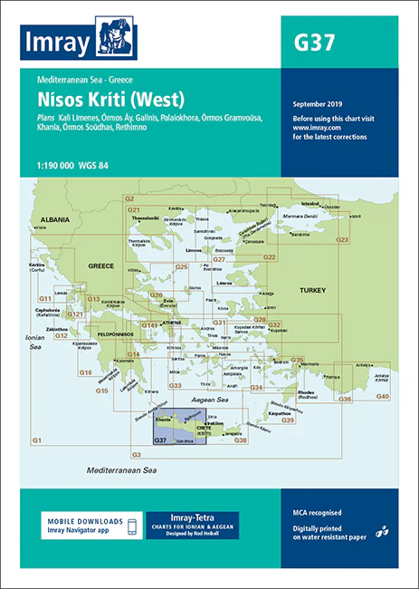
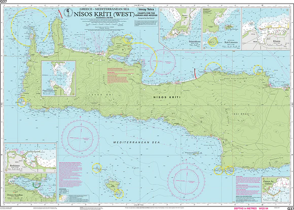
Description
Imray Chart G37 Nísos Kríti (West) – Navigate the Western Coast of Crete with Confidence
Explore the rugged beauty of Crete’s western coast with the Imray Chart G37 Nísos Kríti (West). This detailed navigational chart is essential for sailors navigating the waters around Crete’s western region, offering accurate and comprehensive data to ensure a safe and enjoyable voyage. Whether you’re cruising along the coastline or exploring hidden coves and harbors, this chart is your reliable guide to the stunning landscapes of Western Crete.
Key Features:
- Detailed Coverage: Covers the western section of Crete, including key areas like Chania, Kissamos, and the Elafonisi Peninsula. Perfect for planning coastal passages and exploring the island’s rich maritime heritage.
- Accurate Navigational Data: Includes depth soundings, tidal streams, navigational hazards, and detailed harbor plans, providing you with the critical information needed for safe navigation.
- High-Quality Imray Standards: Renowned for their accuracy and reliability, Imray charts are trusted by mariners around the world for delivering precise and clear navigational information.
- Durable and Weather-Resistant: Printed on marine-grade, water-resistant paper, this chart is designed to withstand harsh marine environments, ensuring it remains intact and readable throughout your journey.
- Up-to-Date Information: Reflects the latest updates and corrections, giving you the most current data available for navigating the western coast of Crete.
Why Choose Imray Chart G37?
- Perfect for Crete Coastal Cruising: Whether you’re on a leisurely sail or an adventurous exploration, this chart provides the detailed information you need to navigate Crete’s western coast with confidence.
- Safety and Precision: With detailed soundings, hazard warnings, and accurate port information, this chart ensures you can navigate safely and find secure anchorages.
- Ideal for Exploration: From bustling ports to secluded bays, this chart offers comprehensive coverage, making it an invaluable tool for sailors looking to discover the natural beauty and hidden treasures of Crete’s western coast.
Ideal For:
- Sailors & Yachters: A must-have for anyone navigating the western coast of Crete, offering reliable data for safe and enjoyable sailing.
- Mediterranean Cruisers: Essential for those cruising the Mediterranean, providing accurate and up-to-date information for planning and executing passages around Crete.
- Adventurers & Explorers: Perfect for those seeking to uncover the hidden gems of Crete’s coastline, with detailed data on anchorages and coastal routes.
Equip yourself with the Imray Chart G37 Nísos Kríti (West) for your next adventure along Crete’s stunning western coastline. Order now to ensure a safe and well-planned voyage.
Plans included:
- Kali Limenes (1:12 500)
- Órmos Áy. Galínis (1:7500)
- Palaiokhora (1:15 000)
- Órmos Gramvoúsa (1:27 500)
- Khanía (1:7500)
- Órmos Soúdhas (1:100 000)
- Rethimno (1:15 000)
On this 2017 edition the latest firing practice areas are shown. The chart specification has been improved to show coloured light flashes. There has been general updating throughout.
PRODUCT INFORMATION
- Stock code: ICG37-1
- Author: Imray G Series
- Publication details: 640 x 900mm folded to A4, Water-resistant paper chart in plastic wallet or flat on request
- Edition date: 2017
- Printed and updated to: January 2023
- ISBN: 9781846239359
Reviews
There are no reviews yet.