Description
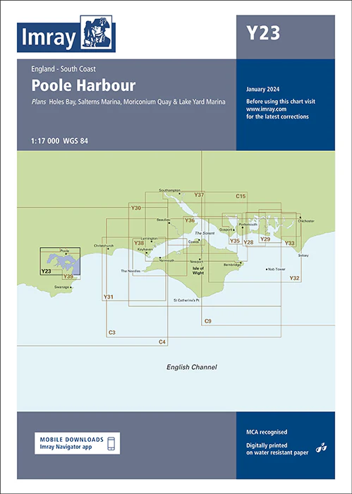
Imray Chart Y23: Poole Harbour – Essential Navigation Chart for Safe and Efficient Boating
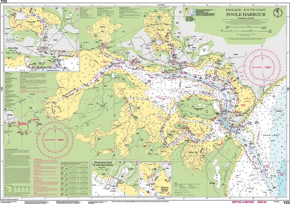
Navigate Poole Harbour with precision and confidence using the Imray Chart Y23. This expertly designed chart provides comprehensive coverage and critical navigational details for one of the UK’s most important and busy harbors, ensuring a safe and enjoyable boating experience.
Key Features:
- Comprehensive Coverage: Offers detailed mapping of Poole Harbour, including essential features such as depth contours, mooring areas, key waypoints, and navigational hazards, perfect for accurate route planning.
- High Accuracy: Created by Imray, a trusted leader in marine navigation charts, guaranteeing reliable and up-to-date information tailored to the unique aspects of Poole Harbour.
- Vital Navigational Data: Includes crucial information on tidal streams, buoy locations, safe passages, and potential hazards, facilitating smooth and safe navigation in and around the harbor.
- Durable and Practical: Printed with high-resolution, waterproof technology on robust paper, ensuring that the chart withstands the demands of marine environments and frequent handling.
- User-Friendly Layout: Designed with a clear, intuitive layout for ease of reading and interpretation, even under challenging conditions or from a distance.
- Seamless Integration: Complements other Imray charts for a cohesive navigation experience, offering continuity and comprehensive coverage of nearby waterways.
Why Choose Imray Chart Y23?
- Trusted Precision: Benefit from Imray’s reputation for accuracy and reliability in marine navigation, providing you with detailed, trustworthy data for Poole Harbour.
- Enhanced Safety: Ensures safe and effective navigation through Poole Harbour, making it an indispensable tool for boaters and sailors in this busy port.
- Improves Navigation Experience: Provides valuable navigational aids and practical information, enhancing your overall boating experience in Poole Harbour.
- Built to Last: Made from waterproof and tear-resistant materials, this chart is designed for durability and longevity in marine conditions.
Ideal For:
- Recreational Boaters: Perfect for leisure boaters, yacht owners, and sailing enthusiasts exploring Poole Harbour for recreation, sport, or local cruises.
- Professional Mariners: A crucial resource for commercial vessels and professional operators navigating Poole Harbour, offering precise and reliable navigational support.
- Local Mariners and Enthusiasts: Essential for those who frequently travel or work in Poole Harbour, providing detailed and tailored navigational guidance.
Ensure accurate and safe navigation in Poole Harbour with the Imray Chart Y23. Order now to secure this essential navigational aid and enhance your boating adventures in one of the UK’s key harbors.
PRODUCT INFORMATION
- Stock code: ICY23-4
- Author: Imray Y Series
- Publication details: 640 x 900mm folded to A4, Water-resistant paper chart in plastic wallet or flat on request
- Edition date: 2022
- Printed and updated to: January 2023
- ISBN: 9781786793492
Reviews
There are no reviews yet.