Description
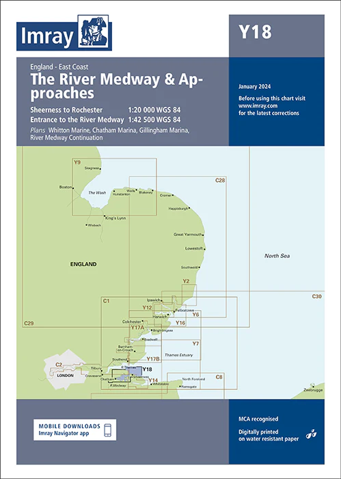
Imray Chart Y18: The River Medway and Approaches – Essential Navigation Guide for Safe River Cruising
Navigate the River Medway and its approaches with precision using the Imray Chart Y18. This detailed and expertly crafted chart is designed to provide sailors and boaters with comprehensive navigational information for a safe and enjoyable journey through this important waterway.
Key Features:
- Detailed Coverage: Offers thorough mapping of the River Medway and its approaches, including essential navigational details such as depth contours, key waypoints, and significant landmarks for accurate route planning.
- High Accuracy: Produced by Imray, a leading name in marine navigation, ensuring reliable and up-to-date information tailored specifically to the River Medway.
- Crucial Navigational Data: Includes vital information on tidal streams, buoy locations, navigational hazards, and safe passages, enabling confident and informed navigation.
- Durable Printing: Features high-resolution, waterproof printing on robust paper, designed to withstand the rigors of the marine environment and frequent handling.
- User-Friendly Design: Designed with a clear, intuitive layout that enhances readability and ease of use, even in challenging conditions or from a distance.
- Seamless Integration: Complements other Imray charts, providing a comprehensive navigation solution for exploring related waterways and ensuring continuity in your journey.
Why Choose Imray Chart Y18?
- Trusted Accuracy: Benefit from Imray’s reputation for precision and reliability in marine navigation, providing you with detailed and accurate data for the River Medway.
- Enhanced Safety: Ensures safe and efficient navigation through the River Medway and its approaches, making it an indispensable tool for anyone traveling these waters.
- Improves Navigation Experience: Offers valuable navigational aids and practical information, enhancing your overall experience on the River Medway.
- Durable and Practical: Made from waterproof and tear-resistant materials, this chart is built to endure frequent use and challenging marine conditions.
Ideal For:
- Recreational Boaters: Perfect for leisure boaters, yacht owners, and sailing enthusiasts exploring the River Medway for recreation, sport, or sightseeing.
- Professional Mariners: A crucial resource for commercial vessels and professional operators navigating the River Medway, providing accurate and reliable navigational support.
- Local Mariners and Enthusiasts: Essential for those who frequently travel or work in the River Medway, offering detailed and tailored navigational guidance.
Ensure precise and safe navigation through the River Medway and its approaches with the Imray Chart Y18. Order now to secure this vital navigational aid and enhance your river cruising experience.
PRODUCT INFORMATION
- Stock code: ICY18-4
- Author: Imray Y Series
- Publication details: 640 x 900mm folded to A4, Water-resistant paper chart in plastic wallet or flat on request
- Edition date: 2024
- Printed and updated to: January 2024
- ISBN: 9781786795625
Reviews
There are no reviews yet.