Description
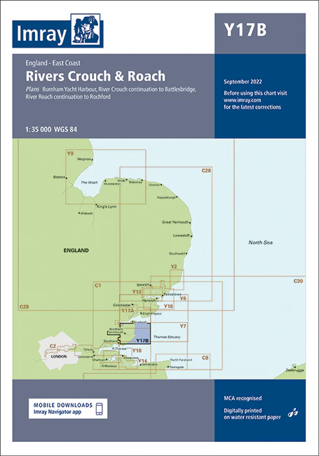
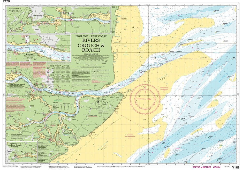
Imray Chart Y17B: The Rivers Crouch and Roach – Essential Navigation Chart for Safe Boating
Explore the stunning Rivers Crouch and Roach with confidence using the Imray Chart Y17B. This meticulously detailed navigation chart is designed to provide comprehensive coverage and vital information for sailors and boaters navigating these beautiful Essex waterways.
Key Features:
- Detailed Coverage: Offers precise mapping of the Rivers Crouch and Roach, including crucial navigational features, depth contours, and key waypoints for accurate route planning.
- High Accuracy: Produced by Imray, a leading authority in marine navigation charts, ensuring the highest levels of accuracy and up-to-date information for these specific rivers.
- Essential Navigational Data: Includes important details such as tidal streams, buoy locations, navigational hazards, and safe passages, facilitating smooth and safe navigation.
- Durable Printing: Features high-resolution, waterproof printing on durable paper that withstands the marine environment, ensuring longevity and ease of use.
- User-Friendly Layout: Designed with an intuitive and clear layout that makes it easy to read and interpret, even in challenging conditions or at a distance.
- Compatible with Other Charts: Complements other Imray charts, providing a seamless navigation experience and comprehensive coverage of adjacent waterways.
Why Choose Imray Chart Y17B?
- Reliable Navigation: Benefit from the precise and dependable data offered by Imray charts, known for their detail and accuracy in maritime navigation.
- Safe and Efficient Travel: Ensures safe navigation through the Rivers Crouch and Roach, making it an indispensable tool for anyone traveling these waterways.
- Enhanced Boating Experience: Provides detailed navigational aids and practical information, enhancing your overall boating experience in these scenic rivers.
- Durable and Practical: Crafted from waterproof and tear-resistant materials, this chart is built to endure frequent handling and challenging marine conditions.
Ideal For:
- Recreational Boaters: Perfect for leisure boaters, yacht owners, and sailing enthusiasts exploring the Rivers Crouch and Roach for leisure, sport, or day trips.
- Professional Mariners: A valuable resource for commercial vessels and operators navigating these rivers, providing accurate and up-to-date navigational information.
- Local Mariners and Enthusiasts: Essential for those who frequently travel or work in these rivers, offering detailed insights and navigational aids tailored to the area.
Navigate the Rivers Crouch and Roach with ease and confidence using the Imray Chart Y17B. Order now to secure this essential navigational tool and ensure safe and enjoyable journeys through these picturesque Essex waterways.
PRODUCT INFORMATION
- Stock code: ICY17B-1
- Author: Imray Y Series
- Publication details: 640 x 900mm folded to A4, Water-resistant paper chart in plastic wallet
- Edition date: 2022
- Printed and updated to: February 2024
- ISBN: 9781786794406
Reviews
There are no reviews yet.