Description
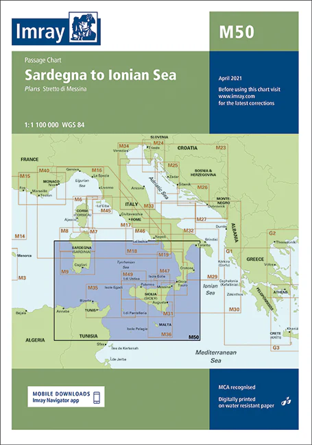
Imray Chart M50 Sardegna to Ionian Sea – Navigate the Mediterranean with Confidence
Explore the captivating waters from Sardegna to the Ionian Sea with the Imray Chart M50 Sardegna to Ionian Sea. This comprehensive navigation chart is an essential tool for sailors, cruisers, and yachters navigating the beautiful and diverse Mediterranean coastline. Offering detailed coverage of the region, it ensures a safe and enjoyable maritime experience.
Key Features:
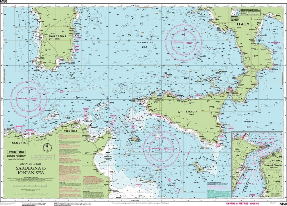
- Comprehensive Coverage: Provides detailed charting from Sardegna (Sardinia) through the Tyrrhenian Sea to the Ionian Sea, including key islands, harbors, and coastal features.
- Precise Navigation Data: Includes up-to-date soundings, tidal information, and navigational hazards to help you navigate safely through this complex and scenic area.
- Clear Cartography: Imray’s high-quality, easy-to-read cartography features detailed markings and labels, making it straightforward to plot your course and identify essential landmarks.
- Durable & Water-Resistant: Printed on robust, water-resistant paper, this chart is designed to withstand the marine environment, providing long-term reliability during your voyages.
- Regular Updates: Incorporates the latest navigational updates and changes to ensure you have the most current and accurate information for your journey.
Why Choose Imray Chart M50?
- Trusted Accuracy: Imray charts are renowned for their precision and reliability, making them a preferred choice for both professional and recreational mariners.
- Enhanced Safety: Provides crucial information to navigate the diverse and picturesque waters between Sardegna and the Ionian Sea, helping to avoid hazards and find safe anchorages.
- Perfect for Planning: Ideal for planning both short trips and extended cruises, offering detailed guidance for effective route planning and navigation through this popular Mediterranean region.
- Portable & Practical: Designed for easy folding and storage, making it a convenient addition to any navigator’s collection.
Ideal For:
- Sailors & Yachters: Essential for navigating the waters between Sardegna and the Ionian Sea, offering detailed information on this stunning and varied maritime region.
- Mediterranean Cruisers: Perfect for those exploring the Mediterranean, providing valuable data for safe navigation through the Tyrrhenian and Ionian Seas.
- Charterers & Day-Trippers: Great for boat rentals and day trips, ensuring reliable and up-to-date information for a safe and enjoyable maritime experience.
Discover the breathtaking beauty and diverse maritime landscapes from Sardegna to the Ionian Sea with the Imray Chart M50. Order now to ensure your Mediterranean adventures are guided by the most accurate and detailed navigational tools available.
Plans included:
- Stretto di Messina (1:125 000)
On this 2017 edition the two new Traffic Separation Schemes off the Algerian coast are shown. The chart specification has been improved to show coloured light flashes. There has been general updating throughout.
PRODUCT INFORMATION
- Stock code: ICM50-2
- Author: Imray M Series
- Publication details: 640 x 900mm folded to A4, Water-resistant paper chart in plastic wallet or flat on request
- Edition date: 2017
- Printed and updated to: April 2022
- ISBN: 9781846239236
Reviews
There are no reviews yet.