Description
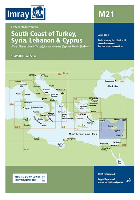
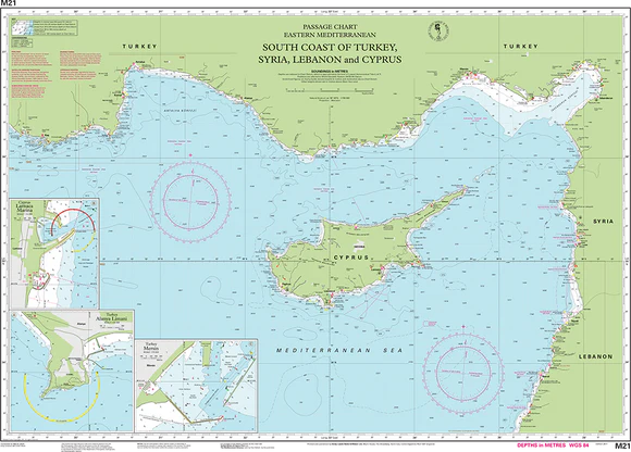
Imray Chart M21 South Coast of Turkey, Syria, Lebanon, and Cyprus – Navigate the Eastern Mediterranean with Precision
Set sail across the beautiful and historically rich waters of the Eastern Mediterranean with the Imray Chart M21 South Coast of Turkey, Syria, Lebanon, and Cyprus. This meticulously detailed navigational chart is a must-have for sailors, cruisers, and yachters exploring the complex coastlines from Turkey to Cyprus. Offering precise, up-to-date information, it ensures safe and informed passage through some of the most captivating maritime regions in the world.
Key Features:
- Comprehensive Regional Coverage: Covers the intricate coastlines of the South Coast of Turkey, Syria, Lebanon, and Cyprus, including major ports, anchorages, and coastal features.
- Accurate Navigational Data: Provides up-to-date soundings, tidal streams, and potential hazards, ensuring safe and reliable navigation throughout these Eastern Mediterranean waters.
- Expert Cartography: Imray’s trusted cartographic expertise ensures high-quality, easy-to-read charts that are essential for effective route planning and on-the-water navigation.
- Durable & Water-Resistant: Printed on premium, water-resistant paper, this chart is built to withstand the harsh marine environment, making it a reliable companion for any voyage.
- Regularly Updated Information: Reflects the latest navigational updates, offering mariners the most current and accurate data available.
Why Choose Imray Chart M21?
- Renowned Accuracy: Imray charts are globally recognized for their precision and reliability, making them a top choice for both professional and recreational mariners.
- Enhanced Safety: Provides essential navigational information that helps you avoid hazards, identify safe anchorages, and make informed decisions, enhancing the safety of your journey.
- Perfect for Planning: Ideal for both short trips and extended cruises, offering detailed guidance on routes, coastal features, and points of interest across the Eastern Mediterranean.
- User-Friendly Design: The clear, organized layout of the chart ensures ease of use, even in challenging conditions, helping you navigate with confidence.
Ideal For:
- Sailors & Yachters: A crucial tool for anyone navigating the South Coast of Turkey, Syria, Lebanon, and Cyprus, offering detailed information on ports, anchorages, and coastal routes.
- Mediterranean Cruisers: Perfect for exploring the diverse and beautiful Eastern Mediterranean, providing essential data for a safe and enjoyable maritime experience.
- Charterers & Coastal Explorers: Great for those renting boats or planning day trips along these historic coasts, ensuring reliable and up-to-date navigational information.
Ensure a safe and memorable voyage through the Eastern Mediterranean with the Imray Chart M21 South Coast of Turkey, Syria, Lebanon, and Cyprus. Order now to equip your vessel with the most accurate and detailed chart for these fascinating maritime regions.
East Mediterranean Sea Passage Chart Imray Chart
Plans:
- Larnaca Marina (Cyprus)
- Mersin (Turkey)
- Alanya Limani (Turkey)
PRODUCT INFORMATION
- Stock code: ICM21-1
- Author: Imray M Series
- Publication details: 640 x 900mm folded to A4, Water-resistant paper in plastic wallet
- Edition date: 2011
- Printed and updated to: April 2023
- ISBN: 9781846233715
Corrections: https://www.imray.com/media/v5lj4ces/m21.pdf
Reviews
There are no reviews yet.