Imray Charts: Navigate with Precision - The History and Value of Imray
For sailors around the world, Imray charts are more than just maps — they’re trusted companions. From the copperplate engravings of the 18th century to the GPS-linked digital charts of today, Imray has shaped the way mariners navigate. For over 200 years, their name has been synonymous with accuracy, clarity, and dependability.
In this in-depth guide, we’ll explore the history of Imray charts, their different series, the unique role of Imray Iolaire charts in Caribbean cruising, and why paper and digital charts still matter in a world of apps and electronics.
Whether you’re a weekend Solent sailor, a Greek island-hopper, or preparing for a transatlantic passage, there’s an Imray chart to guide you safely.


The Origins of Imray Charts
The company we now know simply as Imray began life in the late 1700s as Imray, Laurie, Norie & Wilson Ltd.Based in London, they were one of the first publishers to produce nautical charts and pilot books for commercial and leisure sailors.
At that time, hydrographic data was closely guarded by navies and merchant fleets. Accurate charts were strategic assets, and not widely available to the growing number of recreational sailors. Imray’s founders recognised an opportunity — by publishing commercially available charts, they opened the seas to a much broader audience.
The earliest Imray charts were hand-engraved on copper plates. They were not only accurate but beautiful — part navigational aid, part work of art. Many survive today in maritime museums and private collections, treasured as much for their craftsmanship as their utility.
As Britain entered the 19th century, with its expansion of trade and empire, Imray’s charts became widely used. By the mid-1800s, they had established themselves as the chartmaker of choice for leisure sailors, a role they continue to hold.
Why Imray Charts Became the Standard
Three qualities made Imray stand out in the early years, and they remain relevant today:
-
Accuracy – Imray charts were based on the best available hydrographic data, meticulously updated.
-
Clarity – Unlike some government charts overloaded with technical detail, Imray charts were designed for usability, with sailors in mind.
-
Coverage – They expanded rapidly into popular cruising regions — first the British Isles, then the Mediterranean, and eventually worldwide.
This combination of accuracy, sailor-focused design, and global reach explains why Imray charts remain trusted today.
The Value of Paper Charts in the Digital Age
With electronic plotters, apps, and satellite navigation, some newer sailors ask: Why carry paper charts at all?
The answer comes down to three things:
-
Reliability – Paper Imray charts don’t crash, freeze, or run out of battery. When electronics fail, they’re your safety net.
-
Perspective – A full-size chart spreads out the whole coastline, giving you the “big picture.” A plotter screen often shows only the immediate area.
-
Confidence – Plotting a course by hand on an Imray chart forces you to think like a navigator, not just a passenger following a line on a screen.
That’s why most experienced sailors still carry paper Imray charts — even if they navigate primarily with digital tools.
Key Features of Imray Charts
Over time, Imray charts have earned their reputation for usability. Here’s what makes them special:
-
Regular Updates – Charts are revised frequently, with Notices to Mariners incorporated.
-
Tidal Data – Many charts include tidal stream atlases and ranges.
-
User-Friendly Design – Clear colours, fonts, and symbols. Depth contours and seabed types are easy to interpret.
-
Regional Focus – Charts are grouped into series that cover specific cruising areas.
-
Digital Options – Every paper chart has a digital counterpart, usable on tablets and plotters.
Imray Iolaire Charts: The Caribbean Legacy
No history of Imray is complete without the Imray Iolaire charts, legendary among sailors in the Caribbean.
These charts originated in the 1960s, developed by Don Street, an American yachtsman who cruised extensively in the Lesser Antilles aboard his yawl Iolaire. At the time, reliable charts of the Caribbean were scarce, and many sailors relied on outdated or inaccurate data.
Don Street began producing his own charts, based on local knowledge and meticulous surveying. These became the Imray Iolaire chart series, covering the Caribbean from the Virgin Islands south to Grenada.
The strengths of the Imray Iolaire charts include:
-
Detailed Anchorage Plans – Showing holding ground, hazards, and dinghy landings.
-
Local Knowledge – Notes on customs, mooring fees, and shore facilities.
-
Accuracy in Difficult Waters – Many reefs and shoals were surveyed by Street himself.
Today, the Imray Iolaire charts remain essential for Caribbean sailors, and they carry Don Street’s personal stamp of authority.
Exploring the Imray Chart Series
Imray charts are divided into regional series, combining to give comprehensive coverage of the sailing area from passage charts to coastal detail.
Imray Passage Charts
- The Imray Passage Chart 100 covers the North Atlantic, designed for ocean crossings and offshore routing. Offering a wide-area overview with clear rhumb lines and key waypoints, it helps sailors plan safe transatlantic passages. Essential for bluewater cruisers seeking clarity, reliability, and confidence on long-distance ocean voyages.
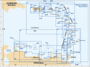
- The Imray Iolaire Chart 1 provides an overview of the entire Eastern Caribbean island chain, from the Virgin Islands down to Grenada. Designed for passage planning, it highlights major routes, anchorages, and hazards. A perfect big-picture companion to detailed Iolaire charts, it’s essential for sailors preparing Caribbean cruising itineraries.
Imray Iolaire A Series
- The Imray Iolaire A Series charts focus on the Leeward Islands, from Antigua and Barbuda through Guadeloupe, Dominica, and Martinique. Combining Don Street’s local knowledge with Imray’s cartographic precision, they provide detailed anchorage plans, reef information, and sailing notes, making them essential for safe navigation in these popular cruising grounds.
Imray Iolaire B Series
- The Imray Iolaire B Series charts cover the Windward Islands from Martinique the north to Trinidad and Tobago in the south. Developed by Don Street and continually updated by Imray, they feature precise anchorage plans, reef details, and local sailing notes, making them indispensable for safe Caribbean cruising.
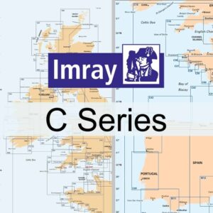
Imray C Series (UK & Ireland)
- The backbone for British sailors. Covering the English Channel, North Sea, Irish Sea, and West Coast of Scotland, these charts are essential for coastal cruising around the UK. From Solent harbour plans to passage charts for the Channel crossing, the C Series Imray charts are indispensable.
Imray Iolaire D Series
- The Imray Iolaire D Series charts cover the southern Caribbean, from Aruba to Tobago. Known for detailed anchorage plans, reef information, and Don Street’s invaluable sailing notes, this series remains the trusted choice for cruisers exploring the idyllic but challenging waters of the southernCaribbean Sea and Windward Islands.
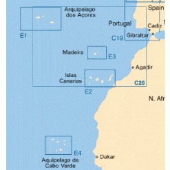
Imray Iolaire E Series
- The Imray E Series charts provide comprehensive coverage of the Atlantic Islands.
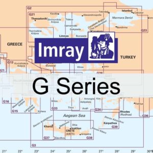
Imray G Series (Greek Waters & Aegean)
- The Imray G Series charts focus on Greek waters, covering the Ionian, Cyclades, Dodecanese, and Aegean coasts of Turkey. Renowned for clarity and accuracy, they provide detailed harbour plans, anchorage notes, and navigational hazards. Essential for island-hopping sailors, the G Series ensures safe and confident cruising in the Aegean and beyond.
Imray M Series (Mediterranean)
- The Imray M Series charts cover the entire Mediterranean, including Spain, France, Italy, Greece, and Turkey, as well as popular islands such as the Balearics and Sardinia. With clear harbour plans, anchorage details, and passage routes, the M Series is the sailor’s trusted companion for exploring Europe’s favourite cruising grounds.
Imray Y Series (European Inland Waterways)
- Providing more detail than can be found on smaller scale charts., the Imray Y Series charts cover eight of the most popular of the UK’s Rivers, Estuaries, and coastal sailing areas.
Passage Planning with Imray Charts
Charts aren’t just for avoiding rocks — they’re central to passage planning. With Imray charts you can:
-
Plot tidal gates and favourable streams.
-
Identify ports of refuge.
-
Mark pilotage plans for harbour entries.
-
Estimate passage times using distance scales.
-
Cross-check routes between paper and digital charts.
Example: Planning a Solent to Cherbourg passage. An Imray C Series chart shows tidal streams across the Channel, traffic separation zones, and detailed plans of Cherbourg approaches — everything you need for safe planning.
How to Read and Use Imray Charts
For those newer to chartwork, here’s a simple step-by-step:
-
Lay Out the Passage – Mark your departure and destination.
-
Check Depths and Hazards – Review depth contours and seabed notes.
-
Plot Courses – Use parallel rulers to draw courses, accounting for leeway.
-
Factor in Tides – Consult tidal data and stream atlases.
-
Note Landmarks and Lights – Cross-check with visual navigation aids.
-
Prepare Alternatives – Always mark at least one refuge harbour.
Imray charts make this process straightforward thanks to their clear design.
The Digital Revolution: Imray Charts Online
Today, Imray offers digital charts alongside paper. Benefits include:
-
GPS Integration – Real-time positioning.
-
Easy Updates – Download corrections instantly.
-
Compatibility – Works with apps and chart plotters.
-
Portability – Carry the whole Med on your tablet.
Many sailors now buy Imray charts online, combining paper and digital for the best of both worlds.
Keeping Charts Updated
Even the best chart is only as good as its update. Imray regularly revises editions, but skippers should:
-
Check chart dates before a voyage.
-
Download the latest digital updates.
-
Replace outdated paper charts every few years.
Imray Charts in Sailing Culture
There’s something iconic about spreading out an Imray chart on a chart table. The familiar blue cover is instantly recognisable, and for many sailors it’s a rite of passage to plot courses on an Imray chart before slipping lines.
Beyond practicality, Imray charts embody tradition. They link today’s sailors with centuries of seamanship. For newcomers, they are a teaching tool; for veterans, a trusted friend.
Why Imray Charts Still Matter Today
Despite the explosion of digital navigation, Imray charts remain vital because they:
-
Provide accuracy and clarity trusted by generations.
-
Combine tradition with modern updates.
-
Deliver both paper reliability and digital convenience.
-
Build sailor confidence — the most important safety tool.
Conclusion: Sail with Confidence Using Imray Charts
From the copperplate engravings of Georgian London to GPS-linked digital apps, Imray charts have guided sailors for over 200 years. Whether you’re cruising UK waters with a C Series, exploring the Med with an M Series, or discovering the Caribbean with Imray Iolaire charts, you’re part of a tradition that blends accuracy, clarity, and trust.
In an age of constant change, Imray charts remain a constant — a reassuring presence on every well-prepared skipper’s chart table.
Fair winds — and keep your Imray charts updated here