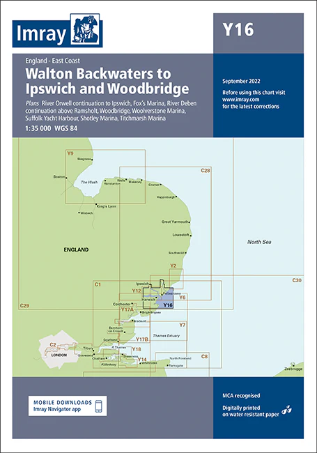
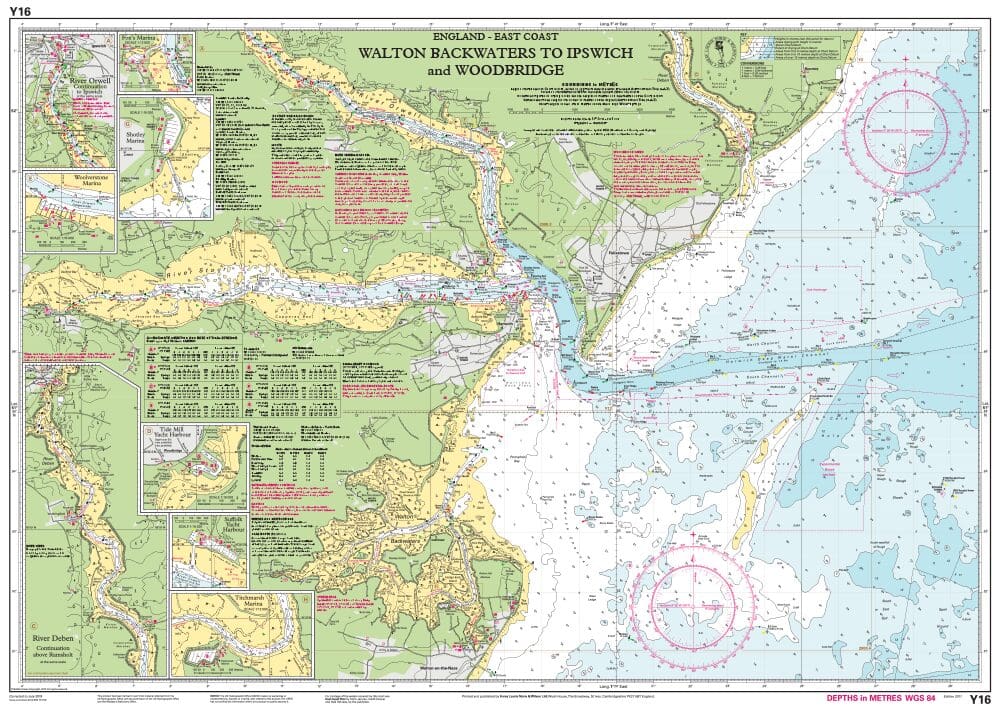
Description
Imray Chart Y16 Walton Backwaters to Ipswich and Woodbridge – Your Essential Guide for East Coast Sailing
Navigate the scenic and intricate waterways of the East Coast of England with the Imray Chart Y16 Walton Backwaters to Ipswich and Woodbridge. This detailed chart provides essential information for sailors exploring the beautiful yet challenging coastal areas from Walton Backwaters through to Ipswich and Woodbridge. Perfect for both experienced sailors and those new to the area, this chart is your go-to resource for safe and enjoyable passage.
Key Features:
- Comprehensive Coverage: Offers detailed charting of the East Coast from Walton Backwaters to Ipswich and Woodbridge, including key ports, harbors, and anchorages.
- Accurate Navigation Details: Features precise soundings, tidal streams, and navigational hazards, ensuring you have all the information needed for safe navigation.
- Easy-to-Read Design: Imray’s clear and concise cartography makes it simple to plot your course and identify important landmarks and features.
- Durable Construction: Printed on water-resistant paper, this chart is designed to endure the marine environment, providing reliable use throughout your voyages.
- Regularly Updated: Reflects the latest updates and changes in the area, ensuring your navigational data is current and accurate.
Why Choose Imray Chart Y16?
- Trusted Quality: Imray charts are known for their precision and reliability, making them a favorite among professional and recreational sailors.
- Essential for Local Navigation: Perfect for exploring the intricate waterways and coastlines of this picturesque region, from tranquil backwaters to bustling harbors.
- Enhance Safety: Provides critical information to help avoid hazards, find safe anchorages, and ensure a smooth passage.
- Portable & Practical: Compact and easy to store, this chart is a convenient tool for both short trips and extended cruising.
Ideal For:
- Sailors & Boaters: Essential for anyone navigating the waters between Walton Backwaters and Woodbridge, whether you’re a local or visiting sailor.
- Cruisers & Day-Trippers: Ideal for those planning day trips or longer cruises in this diverse and scenic region of the East Coast.
- Maritime Enthusiasts: A must-have for anyone interested in exploring the waterways and coastlines of Suffolk and Essex.
Explore the East Coast with confidence using the Imray Chart Y16 Walton Backwaters to Ipswich and Woodbridge. Order now to ensure your sailing adventures are safe, enjoyable, and expertly navigated.
This edition includes the latest official UKHO data, combined with additional information sourced from Imray’s network to make it ideal for small craft. The chart has been fully revised throughout.
Plans included:
River Orwell continuation to Ipswich (1:35 000)
Fox’s Marina (1:10 000)
River Deben continuation above Ramsholt (1:35 000)
Woodbridge (1:15 000)
Woolverstone Marina (1:10 000)
Suffolk Yacht Harbour (1:15 000)
Shotley Marina (1:10 000)
Titchmarsh Marina (1:12 500)
PRODUCT INFORMATION
- Stock code: ICY16-4
- Author: Imray Y Series
- Publication details: 640 x 900mm folded to A4, Water-resistant paper chart in plastic wallet or flat on request
- Edition date: 2022
- Printed and updated to: February 2024
- ISBN: 9781786794185

Reviews
There are no reviews yet.