Description
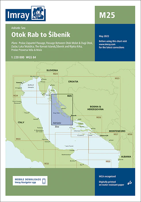
Imray Chart M25 Otok Rab to Šibenik – Navigate Croatia’s Dalmatian Coast with Precision
Explore Croatia’s captivating Dalmatian coast with the Imray Chart M25 Otok Rab to Šibenik. This detailed and accurate navigational chart is a must-have for sailors, yachters, and cruisers venturing between the islands of Otok Rab and the historic city of Šibenik. Imray’s expert cartography provides you with the essential data needed for safe and enjoyable navigation through these picturesque and popular waters.
Key Features:
- Comprehensive Coastal Coverage: This chart covers the Dalmatian coast from Otok Rab to Šibenik, including detailed information on ports, anchorages, and coastal landmarks.
- Accurate Navigational Data: Includes up-to-date soundings, tidal information, and potential hazards, ensuring safe passage through these beautiful Adriatic waters.
- Trusted Cartography: Imray’s renowned charting expertise ensures high-quality, clear, and reliable maps, perfect for effective route planning and on-the-water navigation.
- Marine-Grade Durability: Printed on high-quality, water-resistant paper, this chart is built to withstand the challenges of marine environments, offering long-lasting use.
- Latest Updates: Reflects the most recent navigational updates, providing mariners with the most current and precise information available.
Why Choose Imray Chart M25?
- Renowned Accuracy: Imray charts are known worldwide for their precision and reliability, making them the first choice for both professional and recreational mariners.
- Enhanced Safety: Provides critical navigational information that helps avoid hazards, locate safe anchorages, and make informed decisions, ensuring a safer cruising experience.
- Ideal for Planning: Whether planning a coastal trip or an extended Adriatic cruise, this chart provides detailed guidance to support successful and enjoyable navigation.
- User-Friendly Layout: The clear and organized design of the chart ensures ease of use, even in challenging conditions, helping you navigate with confidence.
Ideal For:
- Sailors & Yachters: Essential for navigating the Adriatic Sea, offering detailed information on ports, anchorages, and safe passages from Otok Rab to Šibenik.
- Dalmatian Coast Cruisers: Perfect for exploring Croatia’s stunning coastlines, providing the necessary data for a safe and memorable sailing adventure.
- Coastal Day-Trippers: Ideal for those renting boats or planning day trips along the Dalmatian coast, ensuring reliable and up-to-date navigational information.
Experience the beauty and history of Croatia’s Dalmatian coast with the confidence that comes from using the Imray Chart M25 Otok Rab to Šibenik. Order now to equip your vessel with the most accurate and detailed chart for this iconic region.
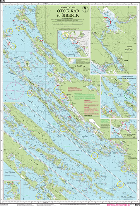
Plans included:
- Prolaz Zapuntel Passage (sketch plan)
- Passage Between Otok Molat & Dugi Otok (1:60 000)
- Zadar (1:25 000)
- Luka Telašćica (1:45 000)
- The Kornati Islands (1:50 000)
- Šibenik and Rijeka Krka (1:50 000)
- Prolaz Proversa Vela & Mala (1:35 000)
PRODUCT INFORMATION
- Stock code: ICM25-3
- Author: Imray M Series
- Publication details: 640 x 900mm folded to A4, Water-resistant paper chart in plastic wallet or flat on request
- Edition date: 2023
- Printed and updated to: May 2023
- ISBN: 9781786794956

Reviews
There are no reviews yet.